Hills-Hornsby Rural Koala Project
Hills-Hornsby Rural Koala Project
The Hills-Hornsby Rural Koala Project is an entirely volunteer run project which investigates the distribution and population density of local koalas by working with the community to map sightings. This mapping is used to advocate for the koala population as well as to identify areas for searching for koalas and other wildlife using field equipment. The project also aims to determine whether our koala population is a stable breeding population.
The background to the Hills-Hornsby Rural Koala Project goes back to the 2002 fires. There was an historic koala population in the area, however much of the natural koala habitat was devastated following the Glenorie bushfires of 2002 and sightings of koalas were not reported for many years.
HHRKP was established in 2018, with the help and support of various local organisations and community members, to gather more information as there was no official research in the area.
Gaining knowledge on the stability, distribution and population density of local koalas can contribute toward protecting koalas and their habitat, to encourage population increase. The project does not focus only on koalas. A big focus of the project is on monitoring biodiversity in the area to upload species data onto the NSW Government’s Bionet database.
While out searching for koalas, the project collects data on all species to upload onto Bionet. The use of song metres and trail cameras has been extremely helpful in recording a wide range of local species, including endangered and threatened species.
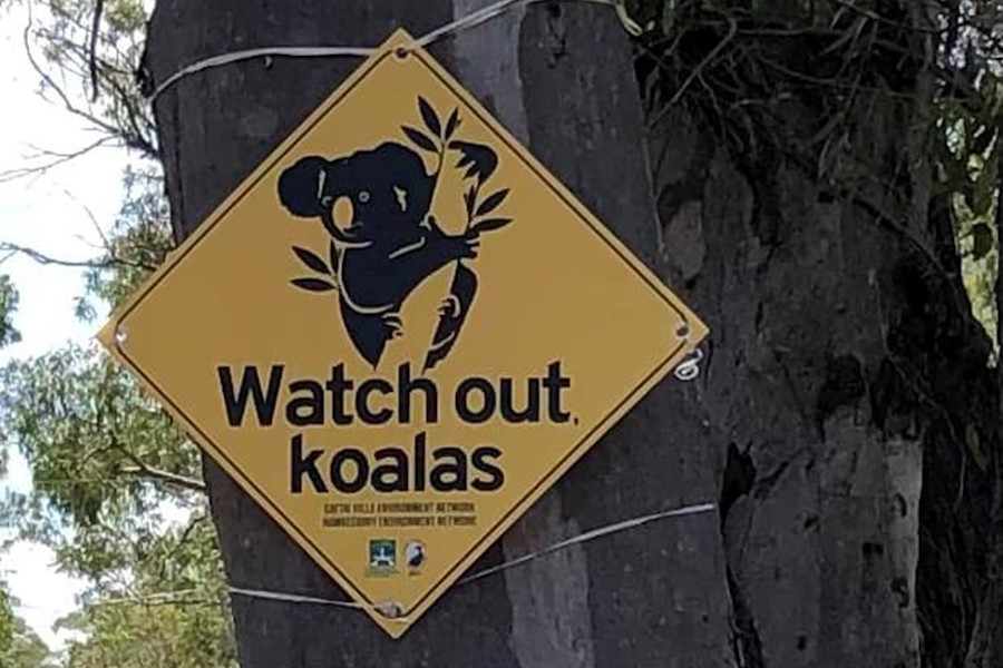
Koala crossing signs have been put up in areas where koalas have been seen near roads, koala scat (droppings) collected and sent for lab analysis, and the project continues to search for koalas and other wildlife using song metres and trail cameras in areas of good habitat where sightings have been mapped.
The project has a wide network of local organisations, ecologists and individuals from the community that contribute, and it is a sub-group of Cattai Hills Environment Network based in Annangrove. Glenorie Environment Centre, Hawkesbury Environment Network and Glenorie Progress Association also work closely with HHRKP.
HHRKP keeps in touch with other koala groups and organisations such as Department of Primary Industries, NSW Koala Strategy, and CSIRO to help ensure the message is getting out that koalas do exist in our area and that their habitat is worth protecting.
Google Earth Koala Sightings
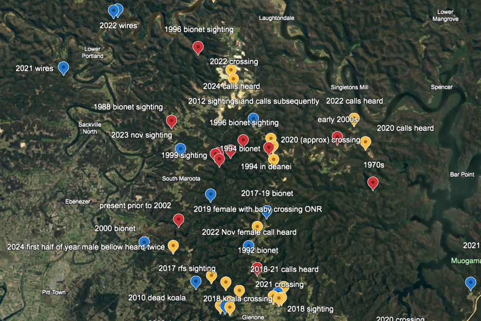
Latest update of koala map including verified and non-verified koala sightings & calls heard over the last 5 years, plus historic data. THANK YOU to all the generous community members who have contributed their sightings or calls heard. This map includes female koalas which by all info we've been given points to a breeding population here rather than a transient one!!!
Over the last five years the HHRKP has mapped koala sightings and calls heard in the Hills and Hornsby areas and so far, has mapped 25 verified and 41 non-verified reports from the public.
Blue = verified
Yellow = non-verified
Red = Historic pre 2002
About HHRKP
Citizen science koala search aiming to determine distribution and population density of local koalas. Also collecting data on local wildlife and uploading to Bionet to have this area recognised for its biodiversity and ecological significance.